BWARS encourages members to submit records electronically. There are two main advantages to the society in receiving electronic records:
- Electronic records save BWARS enormous amounts of time in entering data onto mapping programmes.
- It is very easy to track records when using electronic databases. This means that it is easy for BWARS to find all records for a particular species, county, recorder, or other facet of a record.
Paper Records - If you are unable to submit electronic records, then BWARS is prepared to accept paper records.
Validating your records
Many species of aculeate hymenoptera require critical determination, so recorders should always retain voucher specimens, either at home or by donating them to an appropriate Museum collection. Specimens must always be accompanied by accurate data labels providing details of the location and date of capture.
Recorders who are new to aculeate hymenoptera are advised to seek validation of difficult specimens by BWARS. For advice see the BWARS contacts listed on our contacts page.
Vice County numbers a useful map showing the Watsonian Vice County numbers is at: Vice Counties
To confirm which vice county your record is in use the Botanical Society of the British Isles' tool here
How to submit your records
It is important that the data submitted - be it in computer readable form or not, contains the minimum information, detailed here, in the agreed format and preferably order.
For each record please give:
- The Species name
- The BRC number - the latest species list with BRC numbers can be downloaded here (awaiting file)
- An Ordnance Survey Grid Reference
- Locality - the name of the locality, preferably as named on an OS map
- Date of the record. Give this in the form dd/mm/yyyy e.g. 01/07/2006. IT IS VITAL THAT THIS FORMAT IS USED. If the actual day is not known use 00 for the date of the day.
- Collector - the name of the person who made the record
- Determiner - the name of the person who identified the species recorded
- Source of the data: If a voucher has been held describe where it is held (for species that are difficult to determine a voucher should always be retained)
- Watsonian Vice County name
- Watsonian vice county number
- Further information - if you have any further information related to the record state yes or no. This may be useful for research purposes later.
For paper records please ensure you use a BRC Gen 7 or Gen 13 record card. Available from the Biological Records Centre
Need to find a grid reference?
Try the Ordnance Survey "Get a Map" tool
or the Bedfordshire Natural History Society's excellent grab a grid reference tool which includes aerial photography via Googlemaps
Need to check which Vice County your record is in?
Us the BSBI's tool here
For Channel Islands records, advice on recording locations is given here
SEND RECORDS by email to Mike Edwards (bees wasps and mixed records) and Mike Fox (ants) - see contacts page for details

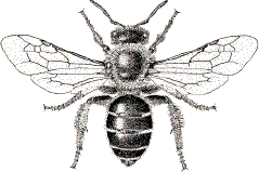
Halictus rubicundus
Drawing: Geoff Allen
What happens to your records?
Submitted data are made available in a controlled way through the National Biodiversity Network's Gateway to a wide range of interested parties. Access to information is provided under strict agreement that users must not republish it, use it to generate any
financial profit, nor exploit it for commercial purpose.
The Society is prepared to consider making data available for specific purposes upon application to the Society via the NBN. Data at 10km resolution is freely available under the general rules and conditions of the NBN.
Species CHECKLIST with BRC numbers
Download a spreadsheet containing species names and BRC numbers, or as tab delimited raw data (right click and select save link as/save target as)
Checklist Spreadsheet [renew link]
Checklist Tab delimited [renew link]
Spreadsheets for records
![]() Download MS Excel spreadsheet, containing headings for required fields
Download MS Excel spreadsheet, containing headings for required fields
OR
![]() Download Open Office Calc spreadsheet, containing headings for required fields
Download Open Office Calc spreadsheet, containing headings for required fields
Mapmate exports
BWARS member Patrick Saunders has written some export queries to allow a few different data exports to replace the existing bwars export in mapmate.

